Geospatial | Drone | AI-ML Solutions
Offering advanced geospatial services tailored to meet your unique business needs and objectives.


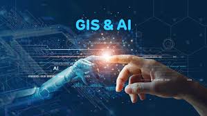
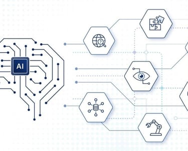
AI-ML Services
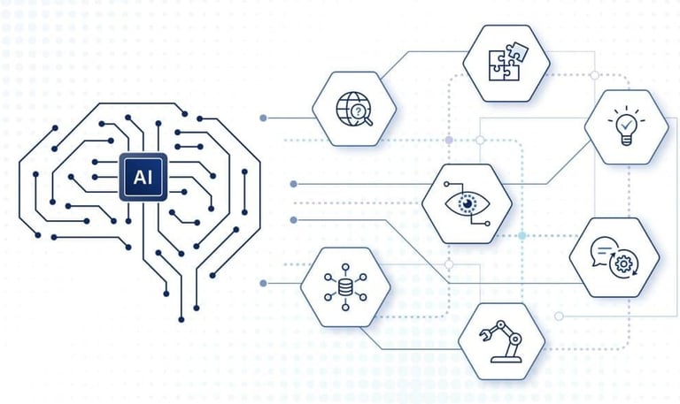
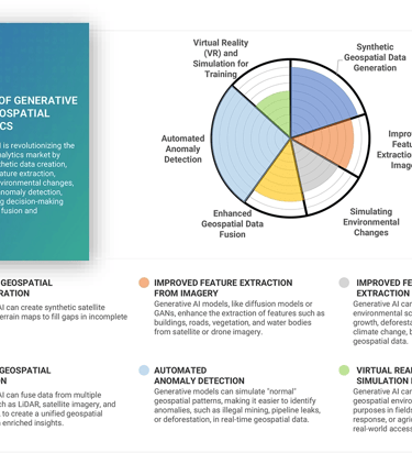
Our Artificial Intelligence (AI) and Machine Learning (ML) services bring automation, accuracy, and predictive intelligence to geospatial and engineering workflows. By integrating AI and ML with GIS, LiDAR, and drone data, we enable automated feature extraction, pattern recognition, and predictive modeling that streamline analysis and enhance decision-making. From detecting infrastructure anomalies and monitoring environmental changes to predicting trends in urban growth and agriculture, our AI-ML solutions transform complex datasets into actionable insights-helping clients optimize operations, reduce costs, and make data-driven strategic decisions.
GIS, LiDAR and Drone Services
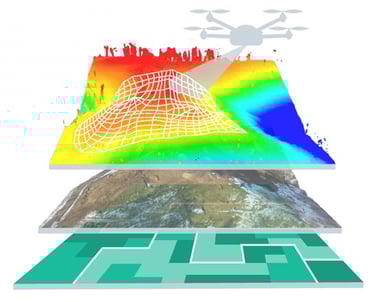
Our GIS, LiDAR, and Drone services work seamlessly together to deliver end-to-end geospatial solutions that empower precise planning, monitoring, and decision-making. Through GIS mapping, we transform spatial data into intelligent visualizations and analytics; our LiDAR technology provides high-resolution 3D terrain and structural models with exceptional accuracy; and our drone surveying and data processing services offer rapid, cost-effective, and detailed aerial insights. Together, these technologies enable us to capture, analyze, and present real-world data with unmatched precision—supporting projects across infrastructure development, environmental management, urban planning, mining, and utilities.
Geospatial Solutions
Expertly crafted geospatial services tailored to your unique needs.
GIS Mapping
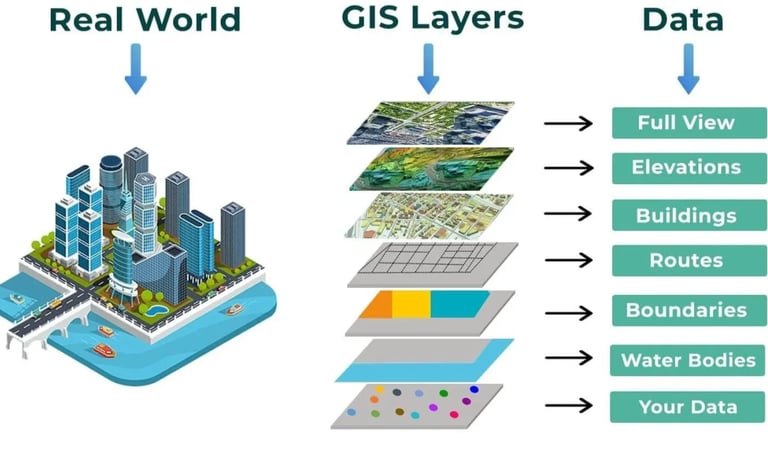
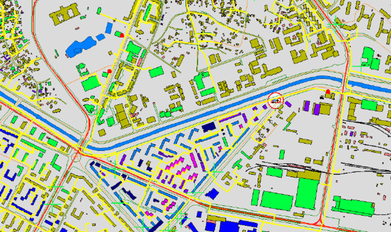
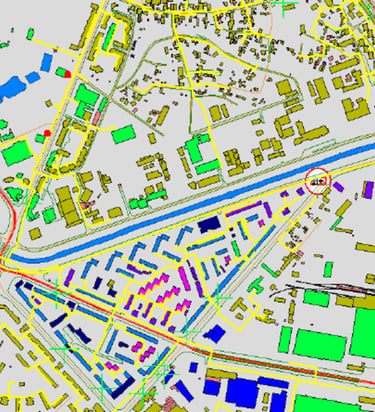
Our Geographic Information System (GIS) services transform spatial data into meaningful insights that drive smarter decision-making. We specialize in building accurate, scalable, and interactive geospatial solutions tailored to meet the diverse needs of industries and government sectors.
Using advanced GIS software and spatial analytics, we capture, manage, and visualize geographic data to create intelligent maps, dashboards, and geodatabases. Our expert team ensures seamless integration of GIS with other technologies such as LiDAR, drone data, and AI-driven analytics for comprehensive spatial intelligence.
We deliver GIS projects across a wide range of applications, including:
Urban and Regional Planning: Developing base maps, land-use plans, zoning maps, and infrastructure layouts to support sustainable urban growth.
Utility and Infrastructure Management: Mapping and managing assets such as pipelines, transmission lines, roads, and telecom networks for better maintenance and planning.
Environmental and Natural Resource Management: Monitoring forests, water bodies, biodiversity, and land degradation for conservation and resource planning.
Disaster Management and Risk Assessment: Creating hazard maps and spatial models to support emergency response, flood risk mapping, and resilience planning.
Agricultural and Land Parcel Mapping: Supporting precision agriculture, irrigation planning, and land ownership verification through geospatial analysis.
Transportation and Logistics Planning: Optimizing routes, analyzing accessibility, and improving transportation infrastructure with spatial data insights.
Our GIS solutions are customized, data-driven, and scalable, helping clients visualize complex relationships, enhance planning efficiency, and make informed strategic decisions.
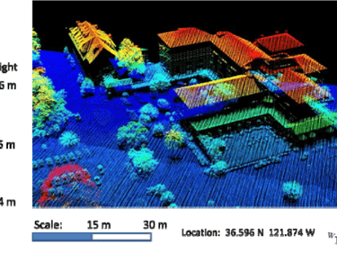
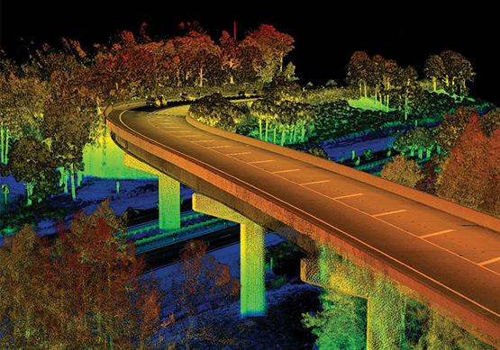
LiDAR Data Processing
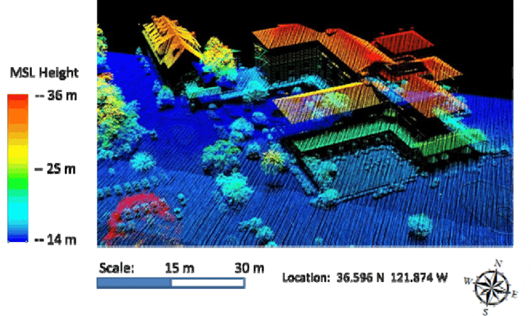
Our LiDAR (Light Detection and Ranging) services deliver high-precision 3D data for detailed terrain mapping and spatial analysis. Using advanced airborne, terrestrial, and drone-mounted LiDAR sensors, we capture millions of data points to create highly accurate digital terrain and surface models.
We handle a wide range of LiDAR projects across multiple industries, including:
Topographic & Contour Mapping: Generating high-resolution elevation models for urban planning, infrastructure development, and environmental assessments.
Transmission Line Surveys: Mapping and monitoring powerline corridors to ensure compliance, safety, and efficient asset management.
Transportation & Infrastructure Projects: Supporting road, railway, and bridge design through accurate 3D mapping and surface modeling.
Mining & Quarry Monitoring: Providing volumetric analysis, pit mapping, and stockpile management for improved operational efficiency.
Forestry & Vegetation Studies: Measuring canopy heights, biomass, and terrain under dense vegetation for sustainable forest management.
Flood Modeling & Watershed Analysis: Producing precise elevation data to support hydrological modeling, flood risk assessment, and drainage planning.
Our LiDAR experts ensure data accuracy, efficient processing, and seamless integration with GIS and CAD platforms—delivering actionable insights that support confident, data-driven decisions.
Drone Mapping Solutions
Expertly crafted geospatial services tailored to your unique needs.
Drone Surveying
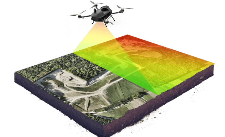
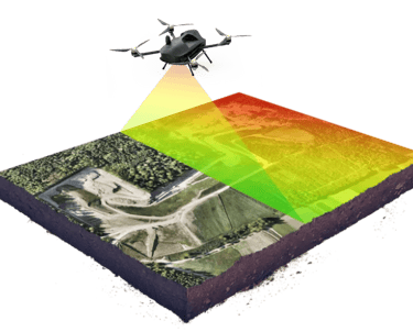
Our drone surveying services combine high-precision aerial imaging with advanced sensors to capture accurate, real-time data across vast and complex terrains. Using cutting-edge UAV technology operated by licensed professionals, we deliver fast, safe, and cost-effective survey solutions that meet the highest industry standards.
We utilize high-resolution cameras, LiDAR sensors, and multispectral imaging to generate detailed aerial maps and 3D models that support precise measurement and analysis. Our workflows ensure seamless integration of aerial data with GIS, CAD, and BIM platforms—providing clients with reliable datasets for planning, design, and monitoring.
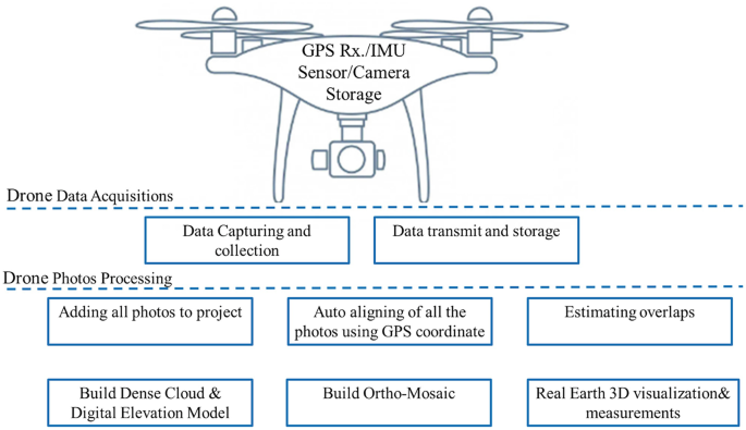
Drone Data Processing
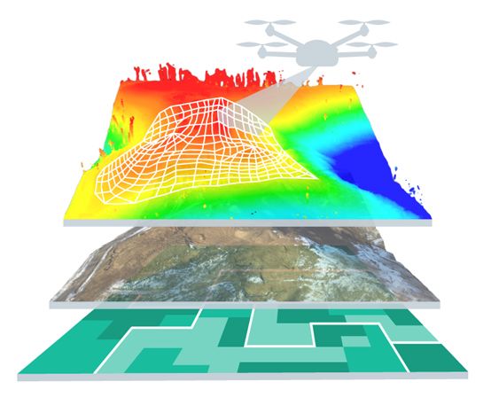
Our drone data processing services transform raw aerial imagery and LiDAR data into accurate, ready-to-use geospatial products that support planning, design, and decision-making. Using advanced photogrammetry and data analytics tools, we process drone-captured data to produce high-resolution maps, 3D models, and analytical outputs tailored to your project requirements.
From field data acquisition to final deliverables, our team ensures precision, consistency, and seamless integration with GIS, CAD, and BIM systems. We apply industry-leading software and AI-driven techniques to extract valuable insights, ensuring that every dataset is optimized for accuracy and usability.
We handle a wide range of drone data processing projects, including:
Orthomosaic Generation: Creating high-resolution, geo-referenced orthophotos for surveying, mapping, and asset documentation.
3D Modeling & Point Cloud Generation: Producing detailed 3D surface and structure models for engineering design, construction monitoring, and visualization.
Digital Elevation Models (DEM) & Digital Terrain Models (DTM): Developing precise elevation datasets to support infrastructure planning, flood modeling, and contour mapping.
Volumetric & Cut-Fill Analysis: Calculating accurate material volumes for mining, earthwork, and stockpile management.
Change Detection & Progress Monitoring: Comparing datasets over time to assess project development, environmental impact, or land use changes.
Vegetation & Environmental Mapping: Analyzing multispectral and thermal data for habitat studies, crop monitoring, and resource management.
Our drone data processing solutions deliver high-accuracy results, faster turnaround times, and actionable insights, empowering clients to visualize, analyze, and manage their projects with greater efficiency and confidence.
AI-ML Solutions
Expertly crafted geospatial services tailored to your unique needs.
Artificial Intelligence
Our Artificial Intelligence (AI) solutions revolutionize the way spatial and survey data are analyzed, interpreted, and utilized. By integrating AI into geospatial workflows, we automate complex data processing tasks, enhance accuracy, and extract deeper insights from massive datasets. Our AI-driven tools help clients streamline operations, reduce manual effort, and make faster, data-informed decisions.
We combine AI with GIS, LiDAR, and drone data to deliver intelligent, adaptive, and predictive geospatial analytics across industries. From pattern recognition to predictive modeling, our AI systems transform raw data into meaningful intelligence that supports better planning, monitoring, and management.
We undertake a wide range of AI-enabled projects, including:
Automated Feature Extraction: Identifying roads, buildings, vegetation, and other land features from satellite, LiDAR, and drone imagery with high precision.
Change Detection & Land Use Classification: Using deep learning models to detect urban growth, deforestation, and land cover changes over time.
Infrastructure Inspection & Monitoring: Applying computer vision to detect structural defects, corrosion, or vegetation encroachment in powerlines, bridges, and utility assets.
Agricultural & Environmental Analytics: Leveraging AI and multispectral imagery to assess crop health, estimate yield, and monitor environmental conditions.
Predictive Maintenance & Asset Management: Using machine learning algorithms to forecast equipment failures or maintenance needs based on historical data and environmental factors.
Object Detection & Counting: Automating the detection and quantification of features such as vehicles, trees, or construction materials for survey and planning purposes.
Our AI solutions deliver automation, accuracy, and advanced insights, enabling organizations to optimize operations, enhance decision-making, and maximize the value of their spatial data.
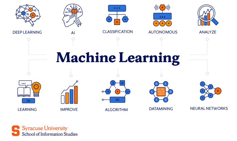
Machine Learning
Our Machine Learning (ML) solutions harness the power of data to uncover patterns, predict trends, and drive intelligent decision-making across geospatial and engineering domains. By training models on large datasets derived from GIS, LiDAR, drone, and IoT sources, we develop automated systems that continuously learn, adapt, and improve over time.
We apply advanced ML algorithms—such as classification, clustering, regression, and neural networks—to process complex spatial and environmental data efficiently and accurately. This enables our clients to gain predictive insights, optimize workflows, and make proactive, evidence-based decisions.
We handle a wide range of machine learning projects, including:
Land Cover & Land Use Classification: Training ML models to automatically classify terrain features such as urban areas, vegetation, water bodies, and bare land from satellite and aerial imagery.
Predictive Analysis for Infrastructure Projects: Using ML to forecast structural degradation, soil stability, and asset performance based on historical and environmental data.
Anomaly Detection in Survey Data: Identifying inconsistencies or errors in LiDAR point clouds, drone imagery, or sensor datasets to ensure data accuracy and reliability.
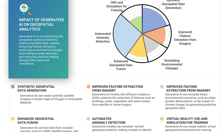
Environmental Monitoring & Forecasting: Applying ML algorithms to predict flood risks, air quality changes, or vegetation growth patterns for sustainable resource management.
Agricultural Intelligence: Leveraging machine learning for crop yield prediction, disease detection, and precision farming recommendations using multispectral and thermal data.
Urban Growth & Change Detection: Analyzing historical spatial data to predict urban expansion trends, aiding in smarter city and infrastructure planning.
Our machine learning solutions deliver data-driven intelligence, automation, and predictive capabilities, helping organizations transform raw geospatial data into actionable insights that enhance efficiency, safety, and sustainability.
Gelände Technology transformed our geospatial projects with their innovative solutions and exceptional client service.
John Doe


★★★★★